Showing posts with label allerton cemetary. Show all posts

Friday, 29 June 2018

FRIDAY FOTO 18 - SARAH ANNE SMITH

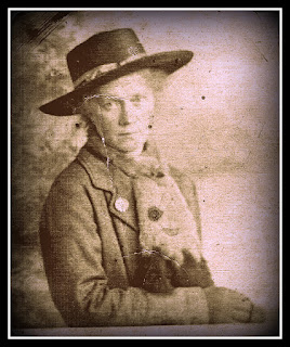
(Sarah Anne Seaman - nee Smith - 1878 to 1951)

This is photo of my great-grandmother, Sarah Anne Seaman (nee Smith). She is pictured standing against a painted backdrop whilst leaning on wooden railing; an apparently posed shot taken in a photographers studio. Unfortunately, no details of the photographer are shown on the original photocard, which appears to have been cut to fit into a frame at some point.  

Sarah was born in 1878 in Liverpool, the eldest child of James Smith and Margaret McCartney.

On the 1891 census her occupation was listed as a dressmakers assistant. She was only 13 years of age.

On 15 April 1900, Sarah married my great-grandfather, Joseph Frederick Seaman in St Dunstans Church, Edge Hill, Liverpool. She was 22 years of age, the same age as her new husband.

In the 1901 census the couple were living at 56 Wendell Street, Toxteth, Liverpool; just off Smithdown Road, occupying 4 rooms in their home. There is an existing property in Wendell Street, a former 'two-up, two-down' terraced house which could therefore be the home of my relatives. However, I am still to confirm when these properties were actually built.  

At the time the census was taken the couple were living in the property with their first child... Mary Cecily Seaman, who was only one month old. The couple went on to have another nine children between them.


Sarah Anne died on the 3 October 1951 in Liverpool and is buried in a marked grave (above) in Allerton Cemetary, Liverpool.

#familyhistory #genealogy #sarahanneseaman #seamanfamilyhistory 

Monday, 9 January 2017

MAPPING MONDAY - USING GOOGLE MY MAPS FOR GENEALOGY

One of the more useful features of Google is the ability to use its Mapping facility to keep track of your genealogical data. For the 'Mapping Monday' article, I thought I’d cover a few of the features available which I use.


Above is the shared version of my Seaman Family Burial Site data. This is the default view which I have chosen to share with the general public, but the view - like the levels of security which you can build into the page - can be tailored exactly as you wish. For example, the base image can reflect Earth data as it is here, or configured to show a more simple map graphic. A selection of different colours can be chosen for this as you prefer.
As you can see, each of the cemetaries listed has been given its own layer on the image. These can be turned on and off using the checkboxes to the left of the menu. Selecting either the name of the relative on the left hand menu or on the icon itself on the map, displays an image and other details of the grave site which have been recorded (see below).


Editing the maps is great fun and can be achieved using the ‘Edit’ option, (which is only accessible to the map owner and any defined collaborators), to access the Google ‘My Maps’ view (below).


The styles and format of each of the layers is configurable separately… allowing features such as the icons, icon colour, text, grouping of labels, level naming conventions etc. to be changed as required. All changes made are saved to Drive, so unwanted changes can be undone if required. Additional items such as new icons, line drawing on the map, and also distance measurement are also available. New layers can also be easily added as required.


As can be seen above, there is also a direction facility which allows you to include this information on a separate layer on the map if required. This information will feed through to the shared map view (so you could include directions to the grave location from the nearest railway station for example), but this data is not configurable to view only users.


Finally, as can be seen in the example above, if images are captured using a smartphone or digital camera with built in GPS, then the exact location of the graves are recorded against the images. When these are placed into the software, the grave locations can be recorded almost exactly, allowing subsequent researchers to the site the best chance of finding the graves for themselves. 


One final example of how these maps can be most useful is to track the migration of families around the country at various times. The example above shows graphically how my LAIT family relations originated in Norfolk with my 5x great-grandfather, Timothy Lait, and finally ended up in Liverpool with my grandmother Margaret Eleanor Graham LAIT, who I am named after. They made a total journey of 409 kms, which took in excess of 159 years, and crossed six generations (eight if you include myself and my father).

So next time you get a little disheartened trying to break down those brick walls in your core data, open up Google, grab yourself an account, and start mapping those ancestors! 
I guarantee that you’ll enjoy it!